Historical Background: In 1823 Francis George Farewell, formerly a lieutenant in the British navy, with other merchants of Cape Town, formed a company to trade with the natives of the southeast coast. In the brig Salisbury, commanded by James S. King, who had been a midshipman in the navy, Farewell visited Port Natal, St Lucia and Delagoa Bays.The voyage was not successful as a trading venture, but Farewell was so impressed with the possibilities of Natal both for trade and colonization that he resolved to establish himself at the port. He went thither with ten companions, among them Henry Francis Fynn. All the rest save Farewell and Fynn speedily repented of their adventure and returned to the Cape, but the two who remained were joined by three sailors, John Cane, Henry Ogle and Thomas Holstead, a lad.
Farewell, Fynn and the others went to the royal kraal of Chaka, and, having cured him of a wound and made him various presents, obtained a document, dated the 7th of August 1824, ceding to F. G. Farewell & Company entire and full possession in perpetuity of a tract of land including the port or harbour of Natal. On the 27th of the same month Farewell hoisted the Union. Jack at the port and declared the territory he British had acquired a British possession.
In 1825 he was joined by King, who had meantime visited England went, and had obtained from the government a letter of recommendation to Lord Charles Somerset, governor of the Cape, granting King permission to settle at Natal. Farewell, King and Fynn made independent settlements at various parts of the bay, where a few Amatuli still lingered.
They lived, practically, as native chiefs, trading with Chaka and gathering round them many refugees from that monarchs tyranny. Early in 1828 King, accompanied by two of Chaka's indunas, voyaged in the Elizabeth and Susan, a small schooner built by the settlers, to Port Elizabeth.
He appears to have been coldly received by the authorities, who were even unable to ascertain the nature of Chaka's embassy. Soon after his return to Natal King died, and in the same month (September 1828) Chaka was murdered by his brother Dingaan. In the December following Farewell went in the Elizabeth and Susan to Port Elizabeth. On this occasion the authorities were more hostile than before to the Natal pioneers, for they confiscated the schooner on the ground that it was unregistered and that it came from a foreign port.
Farewell was not daunted, and in September 1829 set out to return overland to Port Natal. He was, however, murdered in Pondoland by a chief who was at enmity with the Zulus. Fynn thus became leader of the whites at the port, who were much at the mercy of Dingaan.
In 1830, William Wood and his mother embarked on board the cutter "Circe" under Captain Blinkenstock, bound for Port Natal, to join his father, Richard Wood, who was in the employment of Mr. Collis, at the port. The young William Wood soon became an interpreter for Dingaan.
In 1831 that chief raided their settlements, the whites all fleeing south of the Umzimkulu; but at Dingaan's invitation they soon returned. Dingaan declared Fynn his representative and great chief of the Natal Zulus. In 1834, however, Fynn accepted a post under the Cape government and did not return to Natal for many years. It was in this year that a petition from Cape Town merchants asking for the creation of a British colony at Natal was met by the statement that the Cape finances would not permit the establishment of a new dependency.
The merchants, however, despatched an expedition under Dr Andrew Smith to inquire into the possibilities of the country, and the favourable nature of his report induced a party of Dutch farmers under Piet Uys to go thither also. Both Dr Smith and Uys travelled overland through Kaifraria, and were well received by the English living at the bay.
The next step was taken by the settlers at the port, who in 1835 resolved to lay out a town, which they named Durban, after Sir Benjamin dUrban, then governor of Cape Colony. At the same time the settlers, who numbered about 50, sent a memorial to the governor calling attention to the fact that they were acknowledged rulers over a large tract of territory south of the Tugela, and asking that this territory should be proclaimed a British colony under the name of Victoria and that a governor and council be appointed. To all these requests no official answer was returned.
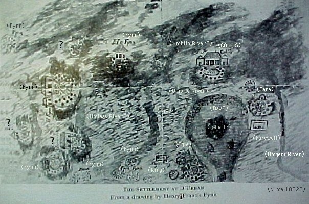
In 1832 Collis was the most important trader in Port Natal and had a house built of mud and reeds. It was the only one with any pretension to European structures. In 1835 Cane, Ogle, Pickman and Collis were established as chiefs. Collis had three or four homesteads.
The settlers had been joined in the year 1835 by Captain Gardiner, a naval officer, whose chief object was the evangelization of the natives. With the support of the traders he founded a mission station on the hill overlooking the bay. He called the station BEREA.
Mr James Collis and his infant child were killed by an explosion in 1835 - his wife and remaining children children left Natal in 1836.
In March/April 1838 the English at the Bay sent two expeditions against the Zulus - the second, culminating in the first Battle of Ndondakusuka (Battle of Tugela) in which of the 17 Whites that sallied forth, only four survived, and of the 800 Black followers 600 perished. Both of Ann Dunn's brothers (sons of AH Biggar) where killed in the action packed 3 months.The brothers Richard Wood and William Wood died on the 16th of April 1838 at the Battle of Tugela.
When the Whites in Port Natal received intelligence of this shocking occurrence and the news of approach of a large body of Dingaan's men they were most concerned. The "Comet" (brig), Capt. Rodham, was then lying in Natal and following are among those who got on board.. The Rev. Mr. Owen, Mrs. Owen, and Miss Owen, Mrs. Champion, Mrs.Adams, the Rev. Mr. Grout, Dr. Adams, Capt. Gardiner, Rev. Mr. Champion, Mrs. Rodham, Mr. Biggar, senior, Mrs. Gardiner, Dr. and Mrs. Towey and child, Charles Adams, Jane Williams, Mr. and Mrs. Dunn and children, Mr. and Mrs. Miller, Mr. and Mrs. Pitman, Mr. and Mrs. Heyward and children, Mr. and Mrs. Hull and children, Mrs. Wood and her son William Wood, Mr. Richard King, Mr. Ogle, George Duffy, Jas.Brown.
On the 11th of May the Comet sailed for Delagoa Bay and ultimately Algoa leaving behind only about 9 of the Port Natal residents. Mrs Dunn and her children were said to be on board. Mr AH Biggar remained in Port Natal and Mr Robert Newton Dunn may have been among the few who remained.
Mrs. Wood and her son William Wood left, in company with Mr. and Mrs. Edwards and family, for Graham's Town on 11 May 1838. The wagon journey to Graham's Town (375 miles as the crow flies) to took a total of 4 months and the WOODs had to walk most of the way. The Edwards family remained in King William's Town. The WOOD family proceeded to Algoa Bay and then boarded the 'Comet" to Cape Town. William WOOD remained in Africa until the age of 20. He then left for Rio de Janeiro, Brazil where he married. After a few years William WOOD and his family moved to England and then on to the United States.
In October 1838 Mr Robert Newton Dunn bought the farm Sea View. The farm was near the property of his father-in-law Mr AH Biggar who was killed in a Zulu ambush on 27 December, 1838. By 1842 Robert Newton Dunn had bought a number of the properties of those killed in the Battle of Tugela and had established a magnificent house and premises at Sea View. It is said that the property enjoyed a view of the ocean.
Sketch of Port Natal - circa 1832This sketch by Henry Francis Fynn shows the location of the homes of the Fynn family and other early settlers. The WOOD family may have acted as caretakers of the COLLIS home both before the arrival of Mrs Collis family and after James Collis died in an explosion.
1831 - March: COLLIS sells his farm and leaves for Graham's Town with party of 10 Europeans & 3 wagons.
1831 - August: James COLLIS and party of Englishmen were in convoy on the way to Port Natal.
1834 - Richard WOOD, (in employ of James Collis), remains in Natal - Dairy of Henry Francis Fynn - P236.
1835 - September. James Collis killed in an explosion - MacKeurtan P184
References: British Settlers in Natal - Vol 4 P149: Diary of Henry Francis Fynn - P207-P209
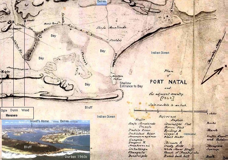
Map of Port Natal 1842.This map shows the original locations of the homes of Ogle, Dunn and Wood. Dunn's house was between the Umbilo (Boiling River) and the Umhlatusi (Umhlatuzana) River (Copper River). Both houses seem to be in the Umbilo River valley close to high ridges. The distance from the Wood home to the mouth of the Umbilo River is just under a mile. The Boer's Camp is almost on the beach and is about a mile from the Wood home.
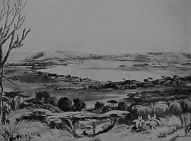
Port Natal Circa 1850.Painting by GF Angus. From the Durban Museum. (see page 33 of 'More Annals of Natal' by AF Hattersley).The Bluff can be seen in the centre left of the painting with the shallow entrance to the Bay immediately below the Bluff. The islands can be seen in the Bay. The buildings are on the 'Commetjes Flat'. This painting was made from the Berea Hills, to the east of where the Wood's home was located.

Settlers Homesteads - Early 1830sThe settlers homesteads are marked on the map below by means of a big dot with smaller dots around the perimeter.
The thatch grass huts were built by Zulu women and come in various sizes. The thatch was tied onto a wooden frame. A kraal would be made up of smaller huts arranged in a circle around a BIG hut.
The huts were waterproof, thermally sound and very comfortable. The floor was made of a mixture of clay and cow dung and could be polished to shine like a good cement floor.
Richard Wood worked for James Collis. Richard's wife and son William arrived on board the cutter "Circe" in 1830. When they first arrive in Port Natal the WOOD family may have - like Cane, Ogle and others settlers - lived in a kraal made up of beehive shaped grass huts.
In 1832 Collis was the most important trader in Port Natal and had a house built of mud and reeds. It was the only one with any pretension to European structures.
In 1836 the American missionaries described the settler's homes as a 'simple habitations' and that at the time (Mr and Mrs) Champion, who opened the school under some trees, lived in a simple native hut.
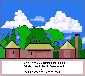
By 1838 the WOOD home could have been like the cluster of little thatched buildings shown in the sketch by Robert Dean Wood. (See the COLLIS house in the sketch of D'Urban by Henry Francis Fynn )
The WOOD home must have been a substantial structure as it is shown on both the 1842 and the 1824 -1842 maps of Port Natal.
There are three locations shown on the 1824 -1842 map of Port Natal that could all have been homesteads belonging to members of the WOOD family.
DUNN's huts, BIGGAR's Farm and the one WOOD property are all located close the the red line marked A-B on this map. The properties are spaced about a half mile apart.
The approximate location of the above three properties, relative to modern Durban suburbs, in shown on a more recent map. See the two maps below this text.

Map of Port Natal 1824 -1842.This map shows the Port Natal Bay and surrounds. The entrance to the Bay was very shallow and the larger ships had to anchor off shore. Port Natal is now called Ethekwini (Durban)
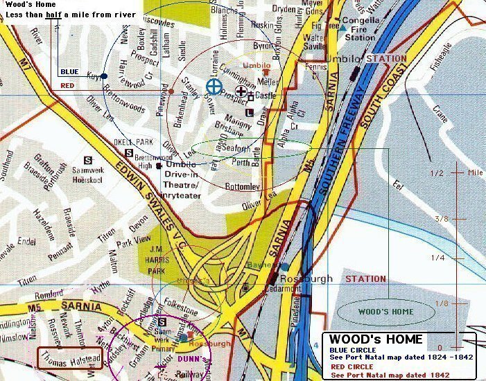
Recent Map of Durban, Natal, South Africa - Suburbs of SeaView, Rossburgh and UmbiloThis map shows the very approximate positions of the homes of the DUNN and WOOD families relative to current landmarks. The Wood's camp was in the area between the Stellawood Cemetery and the Umbilo River. The most likely location of the house - shown on both the Map of Port Natal 1824 -1842 and the Map of Port Natal 1842 as being 3/8 mile north of 'U' bend in the Umbilo river - could have been inside the green ellipse shown on the above map. The 'U' bend, or OXBOW, in the river became an 'L' bend after the construction of the Umbilo River Canal.
The Map of Port Natal 1824 -1842 shows two 'unmarked' camps about 600 metres to the west of the camp marked Wood's - these could have been Wood camps as well. Richard Wood worked for James Collis and one of the camps may have been occupied by his brother William Wood.
Dingaan granted James Collis the whole of Natal in 1834. Collis and his infant child were killed by an explosion in 1835 - his wife and remaining children children left Natal in 1836. After the death of James Collis Dingaan gave Natal to Captain Allen Gardiner. In 1838 Dingaan gave Natal to Piet Retief.
In October 1838 Mr Robert Newton Dunn bought the farm Sea View. The farm was near the property of his father-in-law Mr AH Biggar who was killed in a Zulu ambush on 27 December, 1938. By 1842 Robert Newton Dunn had bought a number of the properties of those killed in the Battle of Tugela and had established a magnificent house and premises at Sea View.

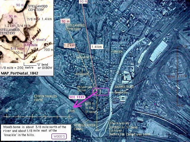
Orthophotographic Map of the area above the bend in the Umbilo RiverThe above orthophotographic map shows the current estimate of the position of the Wood family home relative to circa 1990 landmarks. The map of Port Natal dated 1824-1842 - see insert - shows the WOOD's home as 3/8 mile (600 metre) north of 'U' bend in the Umbilo river.
The map of Port Natal dated 1842 (see next image) shows the WOOD's home to be 1/8 mile (200 metre) east of the southern tip of the bottom of the 'Knuckle' in the hill. This would place the WOOD's home between Seaforth and Perth Roads. Just above the bend in Perth. (Approximate Google Earth Coordinates: -29.894532,30.97844)
Whilst these are estimates of the position of the home the property would have extended for a considerable distance beyond the points shown above.
Orthophotographic Map of the area above the bend in the Umbilo RiverThe above orthophotographic map shows the current estimate of the position of the Wood family home relative to circa 1990 landmarks. The map of Port Natal dated 1824-1842 and the map of Port Natal dated 1842 shows the WOOD's home as 3/8 mile (600 metre) north of 'U' bend in the Umbilo river. Whilst these are estimates of the position of the WOOD's home the property would have extended for a considerable distance around the points shown above.The map dated 1842 shows the 91 metre and 90 metre high 'koppies' in the Stellawood Cemetery as well as a 67 metre 'high point' at the top of Jacob's Ladder on Sarnia Road. This 'high point' is 1 km to the South West of the WOOD's and, together with the distances to the two 'Stellawood' high points, confirms the position of the WOOD's home. See the purple arrow on the above map
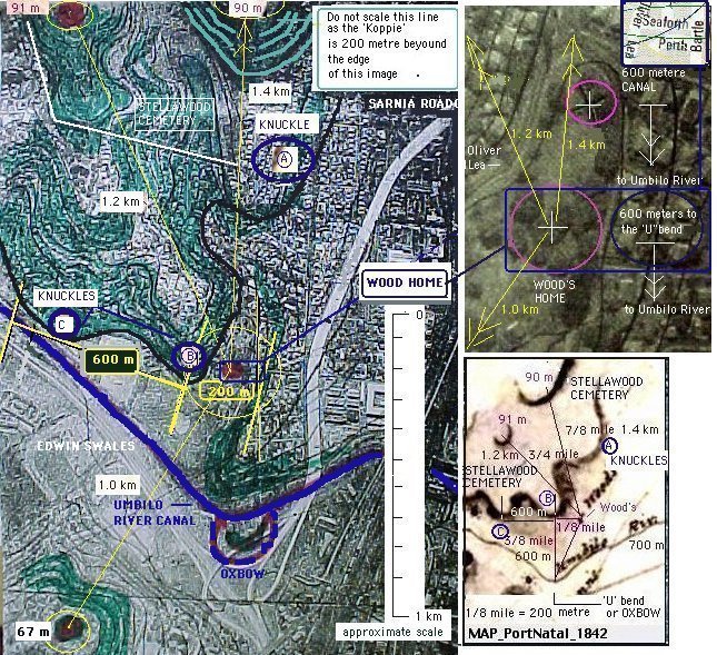
Contours highlighted to show the 'Knuckles' in the Hills south of Stellawood CemeteryComparison between the 'knuckles' in the hills shown in the MAP of Port Natal 1842 and the orthophotographic map of the area places the WOOD's home between Seaforth Road and Perth Road (Place) and about 100 metre west of Bartle Road. Using the 91, 90 and 67 metre 'koppies' places the Wood's home about 200 metre to north west of this point. (Approximate Google Earth Coordinates: -29.894532,30.97844)
There are a number of reasons for the WOODs to have chosen this site for a home. The location was on high and level ground near to a river. The site had a view of the bay to the east. To the west it overlooked a valley that was protected by a range of hills. To the south it overlooked the Umbilo river OXBOW and flood plane. The WOODs were hunters and the records show that this area was teaming with game including Hippopotamus. In the 1840s Robert Newton Dunn (1796 -1847) hunted Hippopotamus in this area - their tusks were used to make false teeth. Dunn is said the have been killed by an elephant near Congella - about a mile to the north east of this site.
In 1846 James Brickhill (1809 - 1899) took title to a property he called 'Prospect' that would have been to the north of the WOOD's home. 'Prospect' was described as the being on the first gentle rise of the Berea Hills after Congella. See 'James Brickhill' Shelagh Spencer's 'British Settlers' Volume 3 page 37.
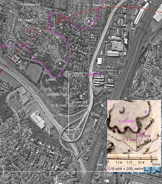
Contours highlighted to show the 'Knuckles' in the Hills south of Stellawood CemeteryThe above is a recent aerial photograph of the area: Once again a comparison between the 'knuckles' in the hills shown in the MAP of Port Natal 1842 and the aerial photograph places the WOOD's home between Seaforth Road and Perth Road (Place) and about 100 metre to the west of Bartle Road.
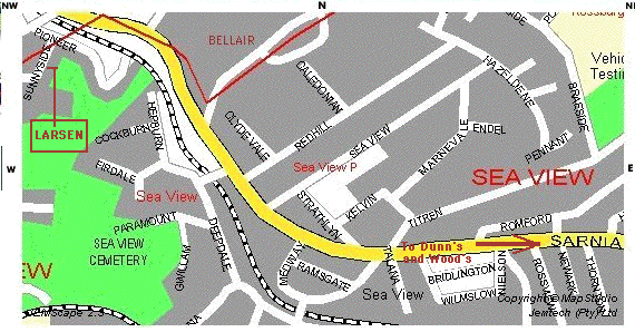
Recent Map of Durban, Natal, South Africa - Suburb of SeaViewRobert Dean Wood wrote: David Larsen lived near the Wood family home when he was a youngster. He first lived in Hereward Road, Umbilo and later moved to Sunnyside Road, SeaView. Hereward Road is within a mile of the Umbilo Railway Station and Sunnyside Road is about 4 miles away, between Rossburgh and Bellair, on the old Sarnia Road to Pinetown and Pietermaritzburg. SeaView is located between the Umhlatuzana and Umbilo Rivers. (David Larsen: larsen@salbu.com) (Robert Dean Wood: rwoodean@attbi.com)
Large 1842 Map of Port Natal (Ethekwini - Durban): Download Image to Disk