From: David Larsen - SALBU <salbu@email.com>
Date: Saturday, July 22, 2006
To: DKOA LIST <dkoa_list@salbu.co.za>
Cc: Lizelle Gregory <lizelleg@mweb.co.za>
Subject: DKOA: PROPOSED TOWNSHIP RIETVLEI ON
PORTION 1 OF THE FARM WITKOPPIES 393-JR
Greetings,
DKOA: See Bokamoso Notice below
PROPOSED TOWNSHIP RIETVLEI ON
PORTION 1 OF THE FARM WITKOPPIES 393-JR
Please see e-mail to Bokamoso and Bokamoso Notice below.
This is the third posting and there have been major changes since the first posting.
For the major changes read the Public Notice copied below and in particular the section headed Project description.
Kind regards,
David Larsen
Secretary: Doornkloof Owners Association (DKOA)
For more information see URL: http://www.salbu.co.za/dkoa
For Maps and Aerial Views of the area see URL: http://www.salbu.co.za/images
Note: These are large images and will take time to download
PS: PLEASE PASS THIS MESSAGE ON TO THREE NEIGHBOURS AND ASK THEM TO DO THE SAME
==========================================================
Telephone: +27-11-316-1393
Mobile: +27-82-821-2202
Fax : +27-88-011-316-1393
Post: Private Bag X2352 Wingate Park, 0153, South Africa.
==========================================================
Lizelle Gregory
Veronika Pinterova Cell: 083 255 8384
P.O. Box 11375
Maroelana Email: lizelleg@mweb.co.za
0161
Dear Lizelle and Veronika,
Bokamoso Notice - PROPOSED TOWNSHIP RIETVLEI
ON PORTION 1 OF THE FARM WITKOPPIES 393-JR
With reference to your noticed copied below.
Please register:
Doornkloof Owners Association (DKOA) as Interested and Affected Parties (I&APs)
As you are aware the Rietvlei Game Reserve is made up of the farms Rietvlei 377-JR and Witkoppies 393-JR. The farms Doornkloof 391-JR, Rietfontein 375-JR and Grootfontein 394-JR border on the Reserve. The farms Sterkfontein 401-JR and Olifantsfontein 402-JR are west of Witkoppies 393-JR and south of Doornkloof 391-JR.
Thank you for your assistance in this matter. We look forward to your further advice and instruction.
Yours sincerely,
David Larsen, SSAS, Pr Eng, MSAIEE, SAAI
Secretary: Doornkloof Owners Association (DKOA)
Wednesday, March 22, 2006 : Time 18:12 SAST
=====================================
01 December 2005
GAUTENG DEPARTMENT OF
AGRICULTURE, CONSERVATION AND
ENVIRONMENT
DIRECTORATE: Environment
ATTENTION: Sakhile
DEAR SIR
RE: PLAN OF STUDY FOR SCOPING:
PROPOSED TOWNSHIP ESTABLISHMENT OF RIETVLEI
ON PORTION 1 OF THE FARM WITKOPPIES 393-JR.
INTRODUCTION
Bokamoso CC was appointed by Chieftain Construction Limited to obtain authorization in terms of the Section 22 of the Environment Conservation Act, 1989 (Act 73 of 1989) in order to commence with the township establishment of Rietvlei on Portion 1 of the farm Witkoppies 393-JR.
PROJECT DESCRIPTION
( DVL Note_060722: This is no longer a valid description as there have been major changes - see Bokamoso Public Notice above)
Project Title: The proposed establishment of Rietvlei on Portion 1 of the farm Witkoppies 393-JR
Property Description: On Portion 1 of the farm Witkoppies 393 –JR.
Name and Address of Chieftain Construction Limited
applicant: P.O Box 8446
Centurion
0046
Contact Person: James Gordon
Tel/fax : (012) 997 6251
Cell: 082 822 8126
E-mail: jgordon@chieftain.ie
Name and Address of Bokamoso Landscape Architects & Environmental
consultants: Consultants
P.O.Box 11375
Maroelana
0161
Contact Person: Lizelle Gregory
Tel: (012) 348 1914
Fax: (012) 348 2365
Cell: 083 255 8384
E-mail: HYPERLINK "mailto:lizelleg@mweb" lizelleg@mweb. co.za
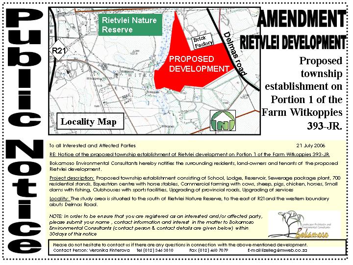
Nature of Activity: (1) Proposed Township establishment consisting of a Retirement village of 250 units and 200 Residential 1 erven; (2) Construction of roads on site; (3) Installation of internal and external services and (4) Upgrading of Provincial Road.
Project Location: The study area is situated to the south of Rietvlei Nature Reserve, to the east of the R21, to the west of Delmas Road (the eastern boundary abuts, Delmas Road) and to the north east of Tembisa and Clayville. (refer to Figure 1,Locality Map).
Size: The study area is approximately 43,2484 hectares in
extent.
Current Land use: Agricultural
Relevant Phases of Preparation Phase
the Development:
Geological, fauna & flora and other specialist input
Environmental process including public participation
Planning and Environmental Approvals
Construction Phase
Installation and construction of the proposed activity
Operational Phase
Operation of the development
Time Frame: Will be supplied in the Scoping Report
Description of Tasks to be performed during Scoping
Methodology:
An investigative approach will be followed and the relevant physical, social and economic
environmental aspects will be assessed in the Scoping Report.
Information that would provide the reader with an objective view of the proposed development will be gathered in the following manner:
The Scoping Report will be prepared in terms of the principles as set out in the EIA
Regulations Guideline Document and the Environment Conservation Act, 1989
(Act 73 of 1989).
The applicant appointed several specialists in order to finalize the services design and geo-
technical report. It is therefore safe to assume that plentiful information is and will be
available for the evaluation of the project.
The written comments submitted by the I& AP’s always proofs to be most helpful in order to
identify the key issues to be mitigated.
The socio-economic and biophysical environment will be investigated.
Red data fauna survey will be conducted.
Red data flora survey will be conducted
A wetland survey will be conducted
A sensitivity map will accompany the above, providing a clear indication of areas of high, medium and low sensitivity.
Bokamoso CC’s impact identification methods include:
Listing all possible issues under the headings of Biophysical, Biological, Cultural and Socio-economic.
Besides professional experience in identifying impacts, the inputs given by the I & AP’s will be assessed and an explanation will be provided in the Scoping Report as to why certain issues raised by I & AP’s were deemed as insignificant and others as significant. The key issues will be evaluated and prioritized with the help of the Project Team.
Alternatives Identified
The No-Go Option
A comparative assessment between the no-go option and the environmental costs of the proposed development will be included as part of the Scoping Report.
Land-Use Alternatives
Other proposed land use and the final layout for the proposed development will be addressed in the Scoping Report.
Priority Issues identified
From the preliminary site visits, by attending some of the project meetings and by analyzing the available data on the study area, it was possible to identify certain issues that will have to be investigated in more detail. These issues are:
1) Natural Environment
Geology and soils
Hydrology
Topography
Climate
Fauna
Flora
Wetland
2) Social Environment
Services
Safety and security
Public Participation
Possible noise, visual, air pollution caused by proposed development on the surrounding
environment
Treatment of existing services and servitudes on the study area.
Economical Environment
Viability of the proposed project
Impact of the proposed development on the adjacent land-values
Methods of Assessing the Significance of Impacts
Geotechnical Engineer
Geotechnical survey – must indicate bad zones
Identification of geology and soils issues for the design of foundation, etc.
Impact identification of proposed development on geology and soils of study area
Mitigation measures and recommendations
Hydrology/ Stormwater specialist
Identification of most significant hydrological issues
Impact identification of proposed development on hydrology of study area and its surroundings
Mitigation measures and recommendations
Fauna Survey
General fauna and red data survey.
Identification of possible issues
Impact identification of proposed development on fauna species of the study area
Recommendations and mitigation measures
Flora Survey
General flora and red data flora survey.
Identification of possible issues
Impact identification of proposed development on the flora species of the study area
Recommendations and mitigation measures
Wetland Survey
Wetland delineation and functional survey assessment
Impact identification of proposed development on wetland
Mitigation measures and recommendations.
Time Schedule For Tasks and Advertising:
Compilation of Report
Assessment of physical, social and economic environmental aspects: 4 weeks
Discussion with provincial authorities, local authorities, other interested and affected parties: 2 weeks
Site survey and photographic recording: 1 week
Completion of report: 6-8 weeks
Public Participation Process
The proposed activity will be advertised in local newspaper and notices will be placed on site and on strategic locations. Apart from inviting comments from interested and affected parties, the immediate neighbouring property owners will notified by flyers and a public open week will be held where project information will be available for comments by the public for one week.
Consultation with the relevant authorities and key interested parties at an early stage in identifying the broad range of issues and alternatives is essential.
Project Timeframes
Will be supplied in the Scoping Report
When Will Authorities Be Consulted?
Province:
The relevant authority will be consulted during the following stages:
accepting of the plan of study for scoping;
accepting of the scoping report;
considering the application of the information contained in the scoping report;
accepting the plan of study for the EIA;
review compliance of EIA; and
consideration of application.
Kungwini Local Municipality:
They will be provided with a copy of the Scoping Report and will provide their comments to GDACE.
Department of Water Affairs and Forestry
They will be provided with a copy of the Scoping Report and will provide their comments to GDACE.
Proposed Method Of Identifying Environmental Issues And Alternatives:
The environmental issues and alternatives will be described and assessed in terms of criteria that have been defined as follows:
Status:
Whether the impact is positive (a benefit), negative (a cost) or neutral.
Duration:
Whether the lifespan of the impact will be short term, 0-5 years, medium term, 5-15 years or long term, greater
than 15 years, with the impact ceasing after the operational life of the development, or considered permanent.
Intensity:
Whether the intensity (magnitude/size) of the impact is high, medium, low or negligible (no impact).
Importance:
The importance of the identified impacts on components of the affected environment shall be described as:
Low - Where the impact will not have an influence on or require significant accommodation
in the project design.
Medium - Where it could have an influence on the environment which will require modification
of the project design or alternative mitigation.
High - Where it could have a “no-go” implication on the project regardless of any possible
mitigation.
Probability of Occurrence:
The probability of the impact actually occurring, as improbable (low likelihood); probable (distinct possibility); highly probable (most likely); or definite (impact will occur regardless of prevention measures).
Extent:
The scale on which the impact will occur, that is whether it will be confined to the immediate areas of the development activity, limited to within 5 km of the development, will it effect the region as a whole, or will it occur on a national or international scale.
Maps to be Included:
Locality plan
Site map
Geology map
Existing land-use (the surrounding area).
The proposed development layout
Sensitivity Map
We trust that you would find this Plan of Study for Scoping in order. Please do not hesitate to contact us if there are any queries on this subject.
Thank You
Yours Sincerely
-------------------------------
LIZELLE GREGORY
PAGE
PAGE 1